So off I went...with a 50 lb pack on my back to help simulate what I would be carrying for the CO hike. I snapped a bunch of photos along the way, posted them here with some commentary.....sit back with some tunes, a beverage, and enjoy (click on the photos to enlarge them...they look much better that way).

This is the Daniel Boone Trail on the way up from the Blue Ridge Parkway...very rocky and rooty.

This is a view of the Linn Cove Viaduct on the Blue Ridge Parkway. This is a segmental concrete bridge winding around a very steep and rocky ledge and was apparently the last section of the Blue Ridge Parkway to be built.

Close up of the Linn Cove Viaduct

Grandfather Mountain is known for having very high winds. Wind speeds over 200mph have been recorded. This is a picture of trees downed by wind. This picture doesn't really do it justice but there were a lot of downed trees in this area as if a big wind shear had taken them all down at once.

Standing at the top of Calloway Peak (5,964 ft), the highest point at Grandfather Mountain, looking south towards McCrae Peak where I'm now headed.

WARNING! A sign at one of the designated camping spots along the trail

Looking back north to where I just hiked from - looking at Watauga Peak (rock cliff in the middle) and Calloway Peak (highest point on the right)

Yes, this is part of the trail...a climb up these rocks. This was easy compared to what was to come.

Working my way towards McCrae Peak, standing at Attic Window area, looking back north from where I just hiked from (Watauga and Calloway Peaks)

Self portait - behind me looking west is Sugar Mountain and Highway 105

Yes, the trail snakes along the cliffs and its very very far down. Not for the faint of heart. I was scared to get too close, especially with the wind whipping up those rock faces.

The trail takes you along these rocky cliffs. I'm getting ready to hike over those rocks down to that next wooded point towards the right.

This is looking down a rocky chute. The wind was gnarly as it was funneling up that chute. I'm getting ready to climb down this chute (with my 50 lb pack on....ridiculous).

Looking back up that rocky chute I just descended

Another part of the trail....going over and under giant rocks

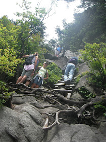
Steep sections with ladders and cables mounted to help you along. Because of my 50lb pack, my center of gravity was way from normal. So I had to be extremely careful and focused with my footing for every single step.

The geological survey marker on top of McCrae Peak - 5,939 ft

On top of McCrae Peak looking down towards the Mile High Swinging Bridge area (and the crowds)

Close up of the Mile High Swinging Bridge and the crowds. They are rebuilding the visitors center there. You can drive your car up to that point. This is where I was headed to meet my family. I didn't see a single soul for the first 3 miles of my hike. Saw a few people the next 2.5 miles. Then the last 1 mile got crowded.

At top of McCrae Peak looking back northeast at the Blue Ridge Parkway

Looking back north at the different peaks I just hiked down from

The last steep section I just descended as I neared my destination (and more crowded as you can see)
It took me almost 2 hours to hike the last 1.5 miles because of all the steep sections, ladders, rock chutes, etc. I don't recommend hiking this section of Grandfather Mountain (around McCrae Peak) with a 50 lb backpack. I want to go back and do it again without the pack. Overall, it was a very beautful day to hike, high temp was low 70s, no humidity, partly cloudy with a nice breeze, and no worries of afternoon storms coming in on this day. Although my heart is in the water (ocean and lakes), I still love the mountains.
I love these mountain diversions. you hit the blogs expecting surf and sailing, but the mountains are so refreshing. excellent. thanks!
ReplyDeleteGeorge, Glad you like it. More to come...going to CO soon. Wishing for wind however....
ReplyDelete