We absolutely loved Sedona, Arizona. The first day in Sedona it admittedly started to feel like “well…it’s just desert and red rock”. But every day we kept discovering new and stunning features. Toward the end of our stay, our hike to the top of Wilson Mountain at 7,000 ft gave us a completely different perspective…one that was higher than the area helicopter tour rides. It was there I said to Kris, “oh, now I get it.”

📍Airport View Trail 1.5 miles, 270 ft elevation gain
Overlooking Sedona from Airport View Trail close to sunset. The light on the red rock formations at this time was incredible.


The town itself feels like your classic mountain town with a river running through it (Oak Creek in this case). It's very nice but a little too “new agey” for my tastes. I’m not really into the whole vortex or southwestern art & jewelry thing but the town seems to really have it together with many roundabouts & a nice trail shuttle system for the most popular trailheads.
We really enjoyed our stay at the Amara Resort & Spa. We found a good room rate deal considering it was in February during the low season. Along with a hot tub and heated pool, plus a nice restaurant (Salt Rock), it was a good location in the uptown area of Sedona located right along Oak Creek with nice views of Snoopy Rock and Lucy Rock.
We noticed all week long and everywhere we went how friendly everyone was in Sedona. Good food too. 89Agave, Golden Goose, Salt Rock, Mesa Grill, Wildflower Cafe, Secret Garden Cafe, Hilltop Deli, Mradaa Cuisine of India, and Basecamp Sedona Beer Co. were all very good but Gerardo’s Pizzeria was an absolute standout. Some of the best pizza we’ve ever had.


📍Bell Rock & Courthouse Butte Loop 4 miles, 400 ft eg
Courthouse Butte during our hike on Bell Rock & Courthouse Butte Loop


Bell Rock


📍Chapel of the Holy Cross (parked at bottom) .5 mile, 100 ft eg

Chapel of the Holy Cross
It was planned a bit at the last minute in mid January. We had read it can get crowded during their high season which starts in March so we opted for a February escape and lucked out on the weather, enjoying sunny low 70s the first couple of days and then sunny 60s the rest of the week. The mornings were nice and chilly in the 40s/50s. It snowed the week before we got there and there was some rain and cooler temps in the following week’s forecast.
The only wildlife we saw was one coyote, a few javelinas (their version of a wild boar/rodent), and a couple of mule deer. No rattlesnakes or scorpions were seen (too cold perhaps?). Apparently, mountain lions and black bears are here but are rarely seen. Unlike other mountain west towns we've visited, there weren't any trailhead signs saying to be on the lookout for bears or mountain lions.
📍Chuckwagon/Mescal/Long Canyon/Deadmans/Fat Tire Loops 19.3 miles, 1700 ft eg

Mountain biking along the Mescal Trail


The real reason I wanted to go - the epic hiking & mountain biking - so many great options in every direction all around Sedona.
In 6 days, Kris & I logged 9 different hikes for a total of 33.5 miles, 6,800 ft elevation gain. The AllTrails app helped guide the way.
I rented a sweet Evil Bike Co mountain bike (The Offering model LS AXS for you bike nerds) from Thunder Mountain Bikes and got in 2 mountain bike rides on various blue/black diamond trails amongst the red rock features for a total of 39 miles, 3,570 ft elevation gain. The MTB Project app helped guide the way.
Hiking:
📍Airport View Trail 1.5 miles, 270 ft elevation gain
📍Bell Rock & Courthouse Butte Loop 4 miles, 400 ft eg
📍Chapel of the Holy Cross (parked at bottom) .5 mile, 100 ft eg
📍Devils Bridge 4.5 miles, 700 ft eg
📍Soldiers Pass (From Sugarloaf trailhead via Teacup Trail, Sinkhole, Seven Sacred Pools, Soldiers Pass Cave) 7.4 miles, 1300 ft eg
📍Raven Caves .6 mile, 130 ft eg
📍Cathedral Rock 2 miles, 700 ft eg
📍Wilson Mountain 9.3 miles, 2550 ft eg
📍Broken Arrow Trail 3.7 miles, 660 ft eg
Mountain Bike Rides:
📍Chuckwagon/Mescal/Long Canyon/Deadmans/Fat Tire Loops 19.3 miles, 1700 ft eg
📍Cathedral Rock Big Loop/Llama Courthouse Vista Loop/Big Park Loop 19.6 miles, 1864 ft eg

Mescal Trail

Chuckwagon Trail

📍Devils Bridge 4.5 miles, 700 ft eg

Our hike to Devil's Bridge

The walk out onto Devil's Bridge is wider than it looks from this angle but still probably not for some who are afraid of heights. Yes, that is a giant open arch underneath us.


📍Cathedral Rock Big Loop/Llama Courthouse Vista Loop/Big Park Loop 19.6 miles, 1864 ft eg
Mountain biking the Cathedral Rock Big Loop


Mountain biking the Llama Courthouse Vista Loop

Biking the Big Park Loop nearby Courthouse Butte

Gerardos Pizzeria was absolutely amazing. A can't miss if you love pizza.

📍Soldiers Pass (From Sugarloaf trailhead via Teacup Trail, Sinkhole, Seven Sacred Pools, Soldiers Pass Cave) 7.4 miles, 1300 ft eg
Hiking the Teacup Trail from the Sugarloaf Trailhead to get to Soldiers Pass Trail / Sinkhole / Seven Sacred Pools / Soldiers Pass Cave


Sinkhole

Seven Sacred Pools

Soldiers Pass Cave


Passing back by Seven Sacred Pools on the way back


A nice post hike brew at Sedona Beer Co Basecamp location in West Sedona

📍Raven Caves .6 mile, 130 ft eg
Raven Caves - a very short walk from the road


📍Cathedral Rock 2 miles, 700 ft eg
The climb up to Cathedral Rock - it required some "3 points of contact" climbing and butt sliding descending


Cathedral Rock


at the end of the Cathedral Rock Trail at the top - well worth the climb with amazing views


Watch out for the cactus. Kris just happened to brush by one and these small fur like pricklers stuck to her jacket and it took some time to pick them off.


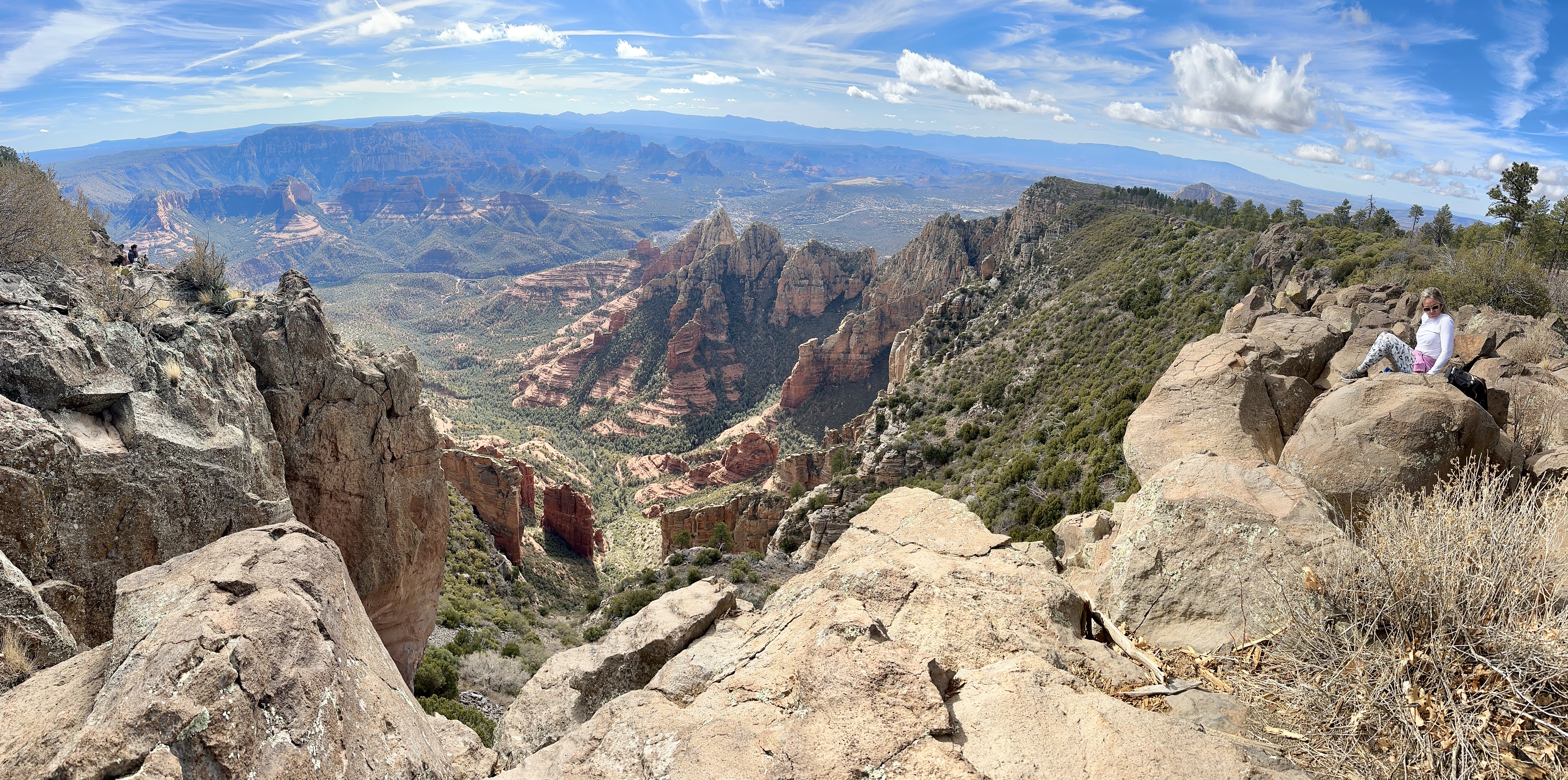
📍Wilson Mountain 9.3 miles, 2550 ft eg


The 4.5 mile constant uphill hike to Wilson Mountain


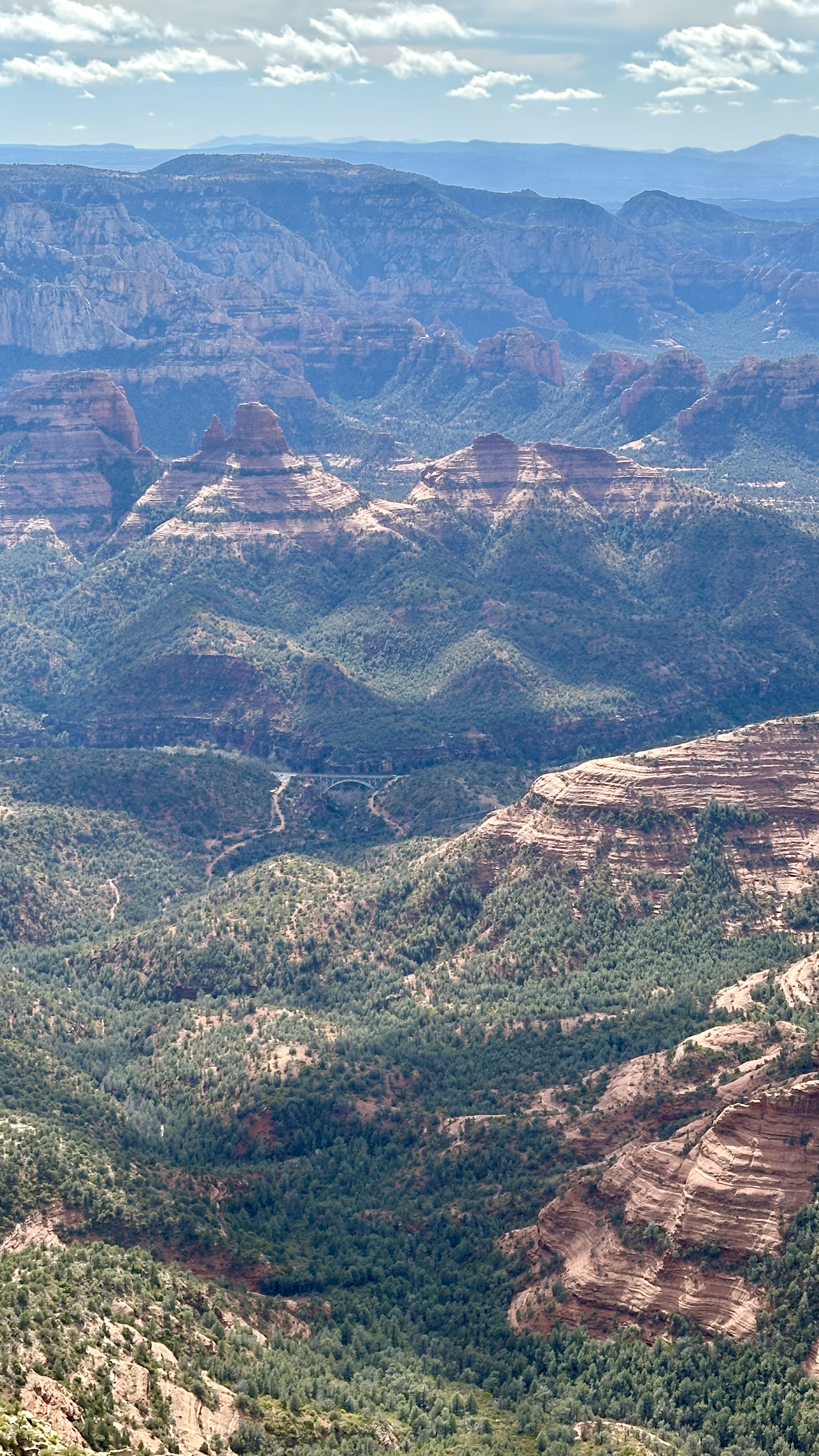


Worth the long hike up for the views - at 7,000 ft, higher than the helicopter tour rides.


Back to the bottom of the trail and looking back up at where we were on Wilson Mountain.


The infinity pool at Amara Resort & Spa - looking at Lucy & Snoopy Rock


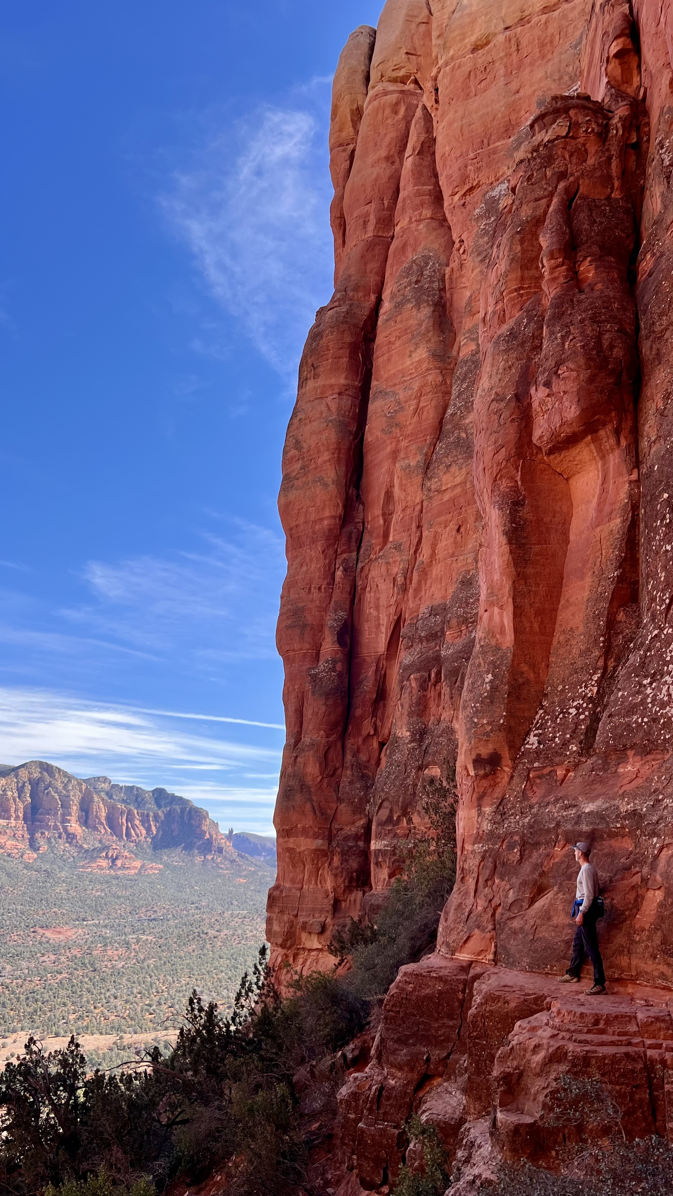
📍Broken Arrow Trail 3.7 miles, 660 ft eg
Broken Arrow Trail


Standing at the beginning of the infamous White Line Trail at the end of the Broken Arrow Trail - search "White Line Mountain Biking" on Youtube to see how risky this trail is to ride. I didn't want to walk any further than this.

Hiking with my nephew & his girlfriend who live nearby and came for a fun visit & hike with us.

Standing at the White Line Trail


1 comment:
Beautiful photos! Thank you so much for sharing your amazing journey. Warm greetings from Montreal, Canada.
Post a Comment